History
Prehistoric Period: Before 1492The Buckingham area contains no known evidence of human habitation that proceeded the period of European settlement. American Indians likely traveled through the area for at least 3000 years preceding this settlement; however, the Indian’s own settlements were generally located near larger rivers and streams than had existed in and near Buckingham.
Colonial Period: 1492-1776Following Christopher Columbus’ 1492 visit to the Americas, the Spanish crown laid claim to the entire North American continent. However, the Spanish did not settle large parts of the continent and were thus unable to fully enforce their claim. Rival European nations therefore issued competing claims upon the continent, which they began to implement by establishing settlements during the early 17th century.
In April, 1606, King James I of England issued a charter to the Virginia Company of London (the London Company), whose first name commemorated the preceding English monarch, Queen Elizabeth I (the “Virgin Queen”). On May 13, 1607, the London Company’s settlers landed on Jamestown Island near the mouth of the James River in tidewater Virginia, where they established “James Citie” (the Jamestown Settlement), the first permanent English settlement in North America.
During the following year, Captain John Smith sailed up the Chesapeake Bay from the Jamestown Settlement to the Potomac River, mapping the River up to the base of Little Falls, near the present site of Chain Bridge. Near the present site of the 14th Street bridges, Smith encountered the residents of an Indian village whose name translated to “Nameroughquena.”
Captain Smith noted at that time that the local Indians, whom he termed “Salvages”, appeared to speak in the Delaware dialect of the Algonquian linguistic group. These “Salvages” were likely Necostins, who were members of the Powhatan Confederacy, a loose grouping of Indian tribes that occupied much of Northern Virginia. However, at the time of Smith’s visit, the Necostins were asserting their independence from Chief Powhatan, who primarily ruled near the James River.
In 1632, England’s King Charles I granted the Potomac River and adjacent lands to the north and east to Cecil Calvert, 2nd Lord Baltimore. Although King Charles was subsequently beheaded, his grant established the northern and eastern limits of Virginia, and ultimately, of Arlington County.
In 1645, Northumberland County was established in Virginia’s Northern Neck, which lay west of the Chesapeake Bay between the Rappahannock and Potomac Rivers. This was the first English county that encompassed Buckingham’s area.
In 1649, King Charles II, while living in exile during the Oliver Cromwell Commonwealth in England, granted all unseated lands in Northumberland County to seven followers, including two Culpeper cousins. Although King Charles lacked the ability to implement his grant at that time, his action established the Northern Neck Proprietary.
In 1653, increasing European settlement created the impetus for the establishment of Westmoreland County in the northern portion of Northumberland County. Five years later, Oliver Cromwell died, and in 1660, the English crown was restored to Charles II.
In 1664, the Buckingham area became a part of Stafford County, which was established at that time in the northern portion of Westmoreland County. In May, 1669, Charles II granted a new charter for the Northern Neck Proprietary. Thomas, 2nd Lord Culpeper, Baron of Thoresbury, and Thomas, 5th Baron of Cameron had by that time acquired the interests of the original grantees. However, neither ever visited their holdings.
Shortly thereafter, in October 1669, the English Crown granted to Captain Robert Howson in exchange for the transportation of 120 settlers a patent that supposedly contained 6000 acres of Northern Virginia land. The area of this patent contained all of the unseated land in an area between the Potomac River and an unsurveyed boundary line that ran one to two miles west of the River from a point on Hunting Creek (the southern border of the future City of Alexandria) in a north-northwest direction to a point near Clarendon on a westward extension of a line that now forms the northern boundaries of Arlington Cemetery and Fort Myer.
The Howson patent was the last royal patent granted in Northern Virginia outside of the Northern Neck Proprietary. Although its actual boundaries had not yet been surveyed, its area encompassed the eastern portions of the present Arlington County and City of Alexandria.
One year after the Crown granted the Howson patent, John Alexander purchased the patent from Captain Howson for 6,000 pounds of tobacco (one pound of tobacco per acre). However, Mr. Alexander chose to live elsewhere.
By 1679, as a result of incursions by hostile Indian tribes from the north and by European settlers, Indians no longer permanently resided in the area that would become Arlington. In 1688, King Charles II granted a final charter for the Northern Neck Proprietary to Thomas, 2nd Lord Culpeper.
Because of the lack of an accurate survey, nobody knew at the time whether the future Buckingham area lay within the Proprietary or whether it lay within the area of Howson patent. Thus, people who presumably owned properties in and near Buckingham had no assurance for many years that they actually held clear titles to their lands.
In 1693, Thomas, 6th Lord Fairfax, 6th Baron of Cameron, was born at Leeds Castle, Kent County, England. Thomas subsequently inherited the Northern Neck Proprietary in 1719.
In 1725, Thomas, Lord Fairfax, while still residing in England, issued to Robert Bates a 525-acre grant in Stafford County that included nearly all of the Buckingham area. In 1730, that area became a part of the new Prince William County.
In 1737, John Warner surveyed the Northern Neck Proprietary for Thomas, Lord Fairfax. His survey showed that the Proprietary, which extended westward from the Chesapeake Bay between outlets of the Rappahannock and Potomac Rivers to the source of the north fork of the Potomac River, contained more than 5.2 million acres.
By 1740, the first known road had been built through the Buckingham area. Later named Glebe Road, this road traveled from the future site of the Town of Alexandria to the future site of Chain Bridge, where Pimmit Run descends in a gentle grade down a narrow valley to the Potomac River. Named for the glebe (the land belonging to a parish church) of Fairfax Parish through which it passed, the road ultimately grew to become a major thoroughfare in Arlington and Alexandria.
A short distance northwest of Buckingham, this road crossed in 1740 a road that traveled between Falls Church and the future site of Rosslyn. Known for many years as the Georgetown- Falls Church Road, the intersecting road became Wilson Blvd during the 20th century. The intersection between the two roads acquired the name of Balls Crossroads (or Balls Crossing) after Ball’s Tavern was built there. As time passed, the intersection became the site of a growing village that acquired the name of Ballston in 1895. As more time passed, Ballston became the western end of the county’s Rosslyn-Ballston development corridor, whose height and density is still increasing.
In 1742, the Buckingham area became a part of Fairfax County. This county, named in honor of Thomas, Lord Fairfax, was created out of the northern portion of Prince William County to accommodate the increasing settlement in the area.
In 1746, Daniel Jennings performed at the request of Gerrard Alexander, a great grandson of John Alexander, the first known survey of the Howson patent. The survey demonstrated that the patent, actually contained 8,000 acres, rather than the 6,000 acres for which John Alexander had earlier paid.
The western boundary of the area that Jennings surveyed passed about one-quarter of a mile east of the present intersection of North Glebe Road and Arlington Boulevard (the east corner of the Buckingham NCP area). The location of this boundary confirmed that Thomas, Lord Fairfax, had properly granted the future Buckingham neighborhood to Robert Bates two decades earlier, as the neighborhood’s site proved to be within the Northern Neck Proprietary, rather than within the area that the Howson patent had encompassed.
In 1747, Thomas, Lord Fairfax, immigrated to Virginia, becoming the first Proprietor of the Northern Neck to live on its property. Except for short intervals, he continued to reside in Virginia until his death in 1781, whereupon the Commonwealth of Virginia confiscated the Proprietary when its heir remained in England.
In 1749, the Virginia General Assembly enacted legislation that created the town of Alexandria on 60 acres of land on the Potomac River north of Hunting Creek. Most of the area’s development gradually extended outward from that focus and from a focus at Georgetown, leaving Buckingham in a rural state for nearly two centuries.
By 1760, Daniel Jennings, Jr., had acquired a property that included the northern part of Buckingham. Jennings, five slaves, and several tenants lived on this property. William Harding owned a property containing the southern part of Buckingham. Four slaves lived on this property.
Revolutionary War to Civil War: 1776 – 1861
The Revolutionary War apparently had little or no impact on the Buckingham area, which was still rural. There is no evidence that troops passed through or fought in the area during the conflict.
In 1791, the first Congress passed legislation that established the location of the federal capital in a 100 square mile territory that Virginia and Maryland would cede to the U.S. government.
However, the legislation contained a provision that prohibited the construction of any federal offices on the Virginia side of the Potomac River. This provision helped ensure that Buckingham would remain rural for nearly one-and-a-half more centuries.
Andrew Ellicott’s 1791-1792 survey of the boundaries of the future District of Columbia placed the portion of Fairfax County that contained Buckingham within the area that Virginia would cede to the federal government. In 1801, an Act of Congress established the County of Alexandria, D.C., within which Buckingham then lay.
Because Alexandria County lacked a strong federal presence, local support developed for a retrocession of the county to the Commonwealth of Virginia. In 1846, Congress authorized the retrocession, and in 1847, the County of Alexandria, Virginia, was organized pursuant to Virginia authorizing legislation.
During this period, the 98-acre Virgil Corbett estate and farm was established in the southeastern part of the Buckingham NC Plan area. At about the same time, Thomas Jefferson Cathcart, a son of James Leander Cathcart (consul to Tripoli and Consul General to Spain under Presidents John Adams, Thomas Jefferson and James Madison) purchased and farmed the portion of the Buckingham area that lay northwest of the future route of Henderson Road.
Civil War to 20th Century: 1861 -1900
In 1861, Virginia seceded from the United States and joined the Confederate States of America. One day after the secession, Union Army troops invaded Alexandria County. Shortly thereafter, Union and Confederate troops skirmished near Balls Crossroads, perhaps in the Buckingham area.
Between 1861 and the end of the Civil War (known in the South as the “War of Northern Aggression” and in the North as the “War of the Rebellion”), the Union Army cut down much of Alexandria County’s woodlands to support their activities and to detect Confederate incursions. In addition, the Army constructed a number of forts and camps throughout Alexandria County, which primarily served as a staging area for the Union’s Army of the Potomac. While none of these facilities were in or near the Buckingham area, the Army raised an observation balloon near Balls Crossroads on several occasions.
After the Civil War ended in 1865, those Virginians who could demonstrate that they had remained loyal to the Union received compensation for losses due to Army activities; those that could not, did not. It is open to question as to whether any of Buckingham’s residents received any such compensation.
In 1870, Alexandria City separated from Alexandria County. The future Buckingham area was placed in the new Arlington Magisterial District of Alexandria County, which had its own courthouse in Alexandria City.
Two other such districts, the Washington Magisterial District and the Jefferson Magisterial Districts, were also established within the county.
By 1878, Alexandria County had constructed near Buckingham the future Carlin Springs Road, which at that time ended at the century-old Georgetown-Falls Church Road (Wilson Blvd.) west of Balls Crossroads. The road, which connected the Balls Crossroads area with the Carlin Springs area south of Four Mile Run, traveled near Lubber Run along the present route of North Abingdon Street west of the Buckingham area, rather than on its present route. At that time, Emily B. Corbett owned a house near Glebe Road in the southeastern portion of the Buckingham area.
In 1886, Arthur W. Cathcart, a mechanical engineer who was a son of Thomas Jefferson Cathcart, married a daughter of Virgil Corbett, merging the Virgil Corbett and Cathcart estates into one family’s ownership. The Cathcart farm, as it was then called, contained nearly all of the property on which the Buckingham neighborhood would later be developed.
In 1893-1894, John B. Henderson, Jr., purchased three adjacent properties totaling 134 acres immediately south of the Cathcart farm. Mr. Henderson, the son of a U.S. senator from Missouri, was a lawyer and diplomat whose primary interests lay in marine biology.
Although his primary residence remained in a mansion in Washington, D.C., Mr. Henderson constructed on his Virginia property in 1894 a two-story wood and plaster Swiss-style house as a country estate. A stone driveway lined by trees led from the house to a road eventually named “Henderson Road” that traveled to Glebe Road through the future Buckingham neighborhood between the properties of the Cathcart and Corbett families.
In 1896, the Washington, Arlington and Falls Church Railroad opened an electric trolley line along the future routes of North Fairfax Drive and Metrorail’s Orange Line. Although the densely-developed Rosslyn-Ballston corridor subsequently grew along its route, the trolley’s major effect on the Buckingham area was to shift the path of development northwards from Balls Crossroads to a new community named Central Ballston that grew along the line.
In 1898, a new Alexandria County Courthouse was constructed near the trolley line close to the present sites of the Arlington County courthouse and office building. Arthur W. Cathcart served on the commission that acquired the property on which Courthouse was built.
Early 20th Century: 1901-1930
By 1908, Arlington County had constructed a road along the present route of North Carlin Springs Road near the future Buckingham area. The road connected the older road from the Carlin Springs area to an intersection on Glebe Road southeast of Balls Crossroads. This intersection now forms the northeast corner of the Buckingham NC Plan area. In 1908, a road named Cathcart Road traveled south from Glebe Road through the Cathcart farm into the future Buckingham NC Plan area.
By 1915, several small buildings had been constructed in the Buckingham area along Glebe Road. Cathcart Road had been extended eastward to reach Fort Myer. After the First World War ended in 1918, Cathcart Road was renamed as Pershing Drive to commemorate General John J. (Black Jack) Pershing.
In 1920, Alexandria County was renamed to Arlington County to reduce confusion with Alexandria City. The Buckingham area remained in the Arlington Magisterial District of the County.
During the 1920’s, automobiles, trucks and buses came into common use, competing with trolleys and railways and creating an impetus for new paved roads. By 1927, a community named Glebewood had developed in the Buckingham area southeast of the intersection of Pershing Drive and Glebe Road, in the vicinity of the future Arlington Boulevard.
South of Glebewood, Swidells Junior College, a girls school which by 1931 had been named Arlington Hall, operated around 1927 on a large property that an entity named Sullins College then owned. Northwest of Glebewood, a new road named Detroit Street traveled in the Buckingham area parallel to Glebe Road, connecting Henderson Road to the present route of North Carlin Springs Road, which at that time was named Carlin Drive.
Mid-20th Century: 1931-1970
In 1931, ground was broken in Falls Church for National Boulevard, the nation’s first transcontinental highway specifically designed for motor vehicles. Soon renamed to Lee Memorial Boulevard and then to Lee Boulevard, the federal government initially expected the highway to travel from Washington, D.C., westward through the South to end near the Pacific Ocean in southern California.
However, the highway was only constructed along its original route in Virginia and Texas. Later designated in Arlington as U.S. Route 50, the 3,073 mile-long road now travels west through the nation’s midsection from Ocean City, Maryland to Sacramento, California, passing near or through Washington, D.C., Cincinnati, St. Louis, Kansas City, central Colorado, Carson City and Lake Tahoe. Although U.S. 50 once crossed California to terminate near the Pacific in San Francisco, an interstate highway replaced its western end in 1972.
In 1932, Arlington County reorganized itself to eliminate its magisterial districts and to become a unitary entity. As part of the reorganization, the county established its present county manager form of government.
In 1933, Lee Boulevard was paved along the present southern border of the Buckingham neighborhood. The paving coincided with the beginning of a period of rapid growth for the federal government in Washington at the start of President Franklin D. Roosevelt’s New Deal.
As a result, Lee Boulevard’s construction gave neighboring property owners an immediate impetus to subdivide their farms and estates and to sell their properties to speculators and developers. Before very long, a number of new residential communities that motor vehicles could conveniently serve would begin to grow near the Boulevard’s route through Arlington.
Around 1935, the Thomas J. Cathcart subdivision was established in the area of the Cathcart farm that lay northwest of Pershing Drive. At the same time, the Parmalee subdivision was established west of Henderson Road near Lee Boulevard, on property that had once been part of the Henderson estate. Thus began the process that would soon replace the area’s farms and estates with buildings, streets, parking lots, young trees and grassy lawns.
By that time, the first part of the future George Mason Drive had been constructed between Lee Boulevard and Henderson Road. Lucy and Sarah Ball owned a parcel of property in that vicinity between Henderson Road and Pershing Drive, north of Lee Boulevard.
Also at about that time, the federal Post Office Department began to plan the construction of a central post office for Arlington County. Located near a trolley line in Clarendon (the county’s primary business area), the central post office would replace a number of individual community post offices that then existed throughout the county.
When making these plans, the Post Office Department found that many Arlington communities had street names and numbers that were similar or identical to those in other communities in the county. As a condition for building the central post office (whose construction began in 1937), the Post Office Department required the county to rename its streets to permit the Department to deliver mail that senders would soon address to Arlington, rather than to community post offices.
In 1935, the county therefore gave new names to many of its streets. The naming system made the new Lee Boulevard a dividing line within the county. Sequentially numbered streets followed by geographical designators crossed the Boulevard (if they reached it). Streets with alphabetically-sequenced names that were preceded by geographical designators traveled parallel to the Boulevard in its vicinity. Many of Arlington’s streets therefore acquired in 1935 such names as First Street North and North Quincy Street north of Lee Boulevard and First Street South and South Quincy Street south of the Boulevard. However, some of these changes did not last very long.
In the Buckingham area, Detroit Street, which had traveled between Carlin Drive (now North Carlin Springs Road) and Henderson Road, became North Utah Street in 1935. However, soon after county renamed Detroit Street, a new extension of the street to North Pershing Drive acquired the inconsistent name of North Thomas Street. The name of this extension appears to have commemorated Thomas Jefferson Cathcart.
Before long, the street’s name and length had changed again. The short section of the street originally named Detroit Street that had been renamed 1935 as North Utah Street became in 1938 the west end of North Thomas Street, which by then extended east of Henderson Road into the Buckingham community. Fortunately for confused area residents and others, some of the area’s major routes (Henderson Road, Glebe Road and Lee Boulevard) kept their older names, at least for a while.
However, the naming of Carlin Springs Road proved to be particularly vexing. In 1931, Carlin Springs Road traveled near Lubber Run to Wilson Boulevard, west of Balls Crossroads. The connecting street that ended at Glebe Road southeast of Balls Crossroads still bore the name of Carlin Drive.
When the county renamed its streets in 1935, Carlin Springs Road became North Abingdon Street. Carlin Drive became North Carlin Springs Road.
However, the county’s 1938 maps misidentified the new route of North Carlin Springs Road as North “Carlyn” Springs Road, perhaps reflecting spelling in the name of the Glencarlyn subdivision, which had earlier borne the name of Carlin Springs. When the county corrected its spelling error around 1970, North Carlyn Springs Road again became North Carlin Springs Road.
When they opened along North “Carlyn” Springs Road in the 1960s, the Buckingham area’s Park Carlyn Apartments and Carlyn Springs Apartments contained the misspelled word within their own names. As their names have not changed, the Apartments continue to memorialize the 1938 misspelling, which remained on official county maps for three decades.
Elsewhere in 1935, Allie S. Freed, Clarence Stein and Henry Wright founded in New York City a company that they named Paramount Communities, Inc. Freed, the company’s president, was the owner of Paramount Motors Corporation (a taxi manufacturer), the chairman of the influential Committee for Economic Recovery and an associate of President Roosevelt. Stein, a developer of several residential communities throughout the nation, served as general manager. Wright, a well-known proponent of the Garden City movement, served as the company’s planner and architect.
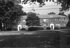
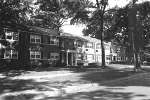
By 1936, Paramount Communities, Inc., had purchased much of the land of the Thomas J. Cathcart subdivision and areas surrounding it between North Carlin Springs Road, North Glebe Road, and Lee Boulevard. In December 1936, Paramount began construction of the Buckingham garden apartment complex through a subsidiary named Buckingham Community, Inc. South of the intersection of North Glebe Road and North Henderson Road, the Buckingham Community developed on the portion of the Thomas J. Cathcart subdivision that Virgil Corbett and his family had earlier farmed during the middle of the 19th century.
Market-rate loans from the New Deal’s Federal Housing Authority financed much of the Buckingham Community’s development. The second major garden apartment complex built in Arlington and one of the largest in the nation, the project was Henry Wright’s last such effort.
Utilizing assembly line methods that Allie Freed had developed at Paramount Motors, the first units of the 1200-unit Buckingham Community opened during 1937. By the time of America’s entry into the Second World War in 1941, the project was largely completed on a 120-acre site surrounding a retail center at the intersection of North Pershing Drive and North Glebe Road.
Freed’s Buckingham Housing Project Planned by Henry Wright
On November 27, 1937, Eleanor Roosevelt (the nation’s First Lady) visited the growing garden apartment complex. She recorded her impressions of the project in her daily “My Day” column, stating, “It is a delightful development … well planned …. gives one a feeling that there is a possibility of doing many things on a community basis that would make life easier for the individual family.”
The developer’s promotional material was no less effusive. In 1941, an advertisement appeared in the Washington Post that stated, “Glamour attaches itself unmistakably to residential life in Buckingham, for this is an apartment community straight from the fountainhead of American culture with all of the charm and loveliness of old America keyed to modern living … so that beauty and economy fuse into inspired perfection.”
Although originally intended for middle income tenants, Buckingham’s promotional efforts attracted many tenants in the upper middle income range. Despite this, the new community failed to charm all of its residents.
In 1938, a group of Buckingham tenants asked Arlington County to declare the community’s incinerator a “public nuisance” because of the smoke and odors that the facility was exhaling.
In 1941, a number of these tenants staged a strike because of the multiple rent increases that their landlord had imposed.
In 1939, the 40-year old electric trolley line along North Fairfax Drive, which at that time was named the Arlington & Fairfax Railroad, ended operations after falling victim to the internal combustion engine, the Depression, and taxpayer-supported road building and paving programs. For the next 40 years, Buckingham’s only nearby form of public transportation would the bus.
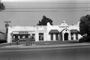
Also in 1939, the Buckingham Theatre opened on the north side of North Glebe Road east of North Pershing Drive. Although the theater is long gone, its building has held since 1990 the latest reincarnation of the Buckingham Post Office, which first opened nearby in 1940 at 301 North Glebe Road.
By 1939, Buckingham Community’s early residents had formed the Buckingham Civic Association, the first of several similarly-named organizations that came and went throughout the years. The Association’s monthly newsletter bore the name of “The Buckaroo.”
In 1940, construction of a portion of the present Arlington Forest community began on the portion of the former Parmalee subdivision that lay immediately south of the present Buckingham NCP area. Developers of the Arlington Forest community preserved woodland on the slopes of the deep valley within which Lubber Run passes through the fall line. This woodland, now in Lubber Run Park, presently separates two portions of the Arlington Forest community from each other.
By 1942, with the Buckingham Community having been largely completed, North George Mason Drive extended from Lee Boulevard past North Pershing Drive to North Henderson Road at the west end of the new development. There the road stopped, blocked by a piece of public property that held the county’s Kate Waller Barrett School.
During and after the Second World War, a U.S. Army officers club occupied the former Henderson residence, a short distance west of the Barrett School. Some of the officers attending the club’s functions likely worked at the nearby Arlington Hall (formerly the Arlington Hall Girls School), which in 1942 had become the home of the U.S. Army’s Signal Intelligence Service (the Army’s code-breaking establishment). In 1993, Arlington Hall became the site of the U.S. State Department’s National Foreign Affairs Training Center, which was renamed in 2002 as the George P. Schultz National Foreign Affairs Training Center.
In 1951, Arlington County acquired the old Henderson residence for use as a recreation center. However, a fire during a 1954 hurricane destroyed the building soon afterwards. The county subsequently replaced the structure with the current Lubber Run Recreation Center.
Also in 1951, the Parkington shopping center opened across Glebe Road from the northwest corner of the Buckingham NC Plan area. Subsequently redeveloped in 1984 by the May Company as Ballston Common mall, Parkington reputedly had one of the largest parking garages in the U.S. when it opened.
In 1952, Lee Boulevard’s name changed to Arlington Boulevard. The change ended twenty years of confusion between the names of the Boulevard and Lee Highway (U.S. Route 29), which both traveled through or near Arlington, Falls Church and Fairfax County.
Between 1945 and 1965, those portions of the Buckingham NCP area not previously developed largely filled up with garden apartments and single family housing. In 1953, the last units of the 1200-unit Buckingham garden apartment complex were completed, ending a twelve year war- time and post-war hiatus during which no new Buckingham Community buildings had opened.
Between 1956 and 1959, North George Mason Drive was extended from North Henderson Road through the county’s Barrett School property to reach North Park Drive. The extension separated a small undeveloped piece of this property north of North George Mason Drive from the school and the remainder of its property south of the Drive. In 2005, the Arlington County Board transferred this forested piece of public property to the county’s Parks division, making it the Buckingham NCP area’s first public park.
By 1961, the county had extended North George Mason Drive from North Park Drive past Lubber Run to North “Carlyn” Springs Road. This extension largely completed the Buckingham NCP area’s presently existing street network. In subsequent years, the county would further extend the Drive both north and south of the Buckingham NC Plan area to enable the Drive to eventually bisect much of the county.
In 1964, Paramount Communities, Inc., built the Chatham Apartments on the north side of Arlington Blvd., west of North George Mason Drive. The building’s name commemorates Chatham Village in Pittsburgh, Pennsylvania, which Clarence Stein and Henry Wright developed in the early 1930’s.
In 1965, the Buckingham Swim Club opened on the northeast side of Glebe Road near the north end of North Henderson Road, providing a much-needed community pool to the growing Buckingham neighborhood. During the same year, the Ku Klux Klan picketed to support continuation of the Buckingham community’s long-standing “whites only” rental policy.
Counter-demonstrators opposing the Klan’s position soon also appeared in the neighborhood. Shortly thereafter, the 1968 federal Fair Housing Act made such arguments moot.
Colonial Period: 1492-1776Following Christopher Columbus’ 1492 visit to the Americas, the Spanish crown laid claim to the entire North American continent. However, the Spanish did not settle large parts of the continent and were thus unable to fully enforce their claim. Rival European nations therefore issued competing claims upon the continent, which they began to implement by establishing settlements during the early 17th century.
In April, 1606, King James I of England issued a charter to the Virginia Company of London (the London Company), whose first name commemorated the preceding English monarch, Queen Elizabeth I (the “Virgin Queen”). On May 13, 1607, the London Company’s settlers landed on Jamestown Island near the mouth of the James River in tidewater Virginia, where they established “James Citie” (the Jamestown Settlement), the first permanent English settlement in North America.
During the following year, Captain John Smith sailed up the Chesapeake Bay from the Jamestown Settlement to the Potomac River, mapping the River up to the base of Little Falls, near the present site of Chain Bridge. Near the present site of the 14th Street bridges, Smith encountered the residents of an Indian village whose name translated to “Nameroughquena.”
Captain Smith noted at that time that the local Indians, whom he termed “Salvages”, appeared to speak in the Delaware dialect of the Algonquian linguistic group. These “Salvages” were likely Necostins, who were members of the Powhatan Confederacy, a loose grouping of Indian tribes that occupied much of Northern Virginia. However, at the time of Smith’s visit, the Necostins were asserting their independence from Chief Powhatan, who primarily ruled near the James River.
In 1632, England’s King Charles I granted the Potomac River and adjacent lands to the north and east to Cecil Calvert, 2nd Lord Baltimore. Although King Charles was subsequently beheaded, his grant established the northern and eastern limits of Virginia, and ultimately, of Arlington County.
In 1645, Northumberland County was established in Virginia’s Northern Neck, which lay west of the Chesapeake Bay between the Rappahannock and Potomac Rivers. This was the first English county that encompassed Buckingham’s area.
In 1649, King Charles II, while living in exile during the Oliver Cromwell Commonwealth in England, granted all unseated lands in Northumberland County to seven followers, including two Culpeper cousins. Although King Charles lacked the ability to implement his grant at that time, his action established the Northern Neck Proprietary.
In 1653, increasing European settlement created the impetus for the establishment of Westmoreland County in the northern portion of Northumberland County. Five years later, Oliver Cromwell died, and in 1660, the English crown was restored to Charles II.
In 1664, the Buckingham area became a part of Stafford County, which was established at that time in the northern portion of Westmoreland County. In May, 1669, Charles II granted a new charter for the Northern Neck Proprietary. Thomas, 2nd Lord Culpeper, Baron of Thoresbury, and Thomas, 5th Baron of Cameron had by that time acquired the interests of the original grantees. However, neither ever visited their holdings.
Shortly thereafter, in October 1669, the English Crown granted to Captain Robert Howson in exchange for the transportation of 120 settlers a patent that supposedly contained 6000 acres of Northern Virginia land. The area of this patent contained all of the unseated land in an area between the Potomac River and an unsurveyed boundary line that ran one to two miles west of the River from a point on Hunting Creek (the southern border of the future City of Alexandria) in a north-northwest direction to a point near Clarendon on a westward extension of a line that now forms the northern boundaries of Arlington Cemetery and Fort Myer.
The Howson patent was the last royal patent granted in Northern Virginia outside of the Northern Neck Proprietary. Although its actual boundaries had not yet been surveyed, its area encompassed the eastern portions of the present Arlington County and City of Alexandria.
One year after the Crown granted the Howson patent, John Alexander purchased the patent from Captain Howson for 6,000 pounds of tobacco (one pound of tobacco per acre). However, Mr. Alexander chose to live elsewhere.
By 1679, as a result of incursions by hostile Indian tribes from the north and by European settlers, Indians no longer permanently resided in the area that would become Arlington. In 1688, King Charles II granted a final charter for the Northern Neck Proprietary to Thomas, 2nd Lord Culpeper.
Because of the lack of an accurate survey, nobody knew at the time whether the future Buckingham area lay within the Proprietary or whether it lay within the area of Howson patent. Thus, people who presumably owned properties in and near Buckingham had no assurance for many years that they actually held clear titles to their lands.
In 1693, Thomas, 6th Lord Fairfax, 6th Baron of Cameron, was born at Leeds Castle, Kent County, England. Thomas subsequently inherited the Northern Neck Proprietary in 1719.
In 1725, Thomas, Lord Fairfax, while still residing in England, issued to Robert Bates a 525-acre grant in Stafford County that included nearly all of the Buckingham area. In 1730, that area became a part of the new Prince William County.
In 1737, John Warner surveyed the Northern Neck Proprietary for Thomas, Lord Fairfax. His survey showed that the Proprietary, which extended westward from the Chesapeake Bay between outlets of the Rappahannock and Potomac Rivers to the source of the north fork of the Potomac River, contained more than 5.2 million acres.
By 1740, the first known road had been built through the Buckingham area. Later named Glebe Road, this road traveled from the future site of the Town of Alexandria to the future site of Chain Bridge, where Pimmit Run descends in a gentle grade down a narrow valley to the Potomac River. Named for the glebe (the land belonging to a parish church) of Fairfax Parish through which it passed, the road ultimately grew to become a major thoroughfare in Arlington and Alexandria.
A short distance northwest of Buckingham, this road crossed in 1740 a road that traveled between Falls Church and the future site of Rosslyn. Known for many years as the Georgetown- Falls Church Road, the intersecting road became Wilson Blvd during the 20th century. The intersection between the two roads acquired the name of Balls Crossroads (or Balls Crossing) after Ball’s Tavern was built there. As time passed, the intersection became the site of a growing village that acquired the name of Ballston in 1895. As more time passed, Ballston became the western end of the county’s Rosslyn-Ballston development corridor, whose height and density is still increasing.
In 1742, the Buckingham area became a part of Fairfax County. This county, named in honor of Thomas, Lord Fairfax, was created out of the northern portion of Prince William County to accommodate the increasing settlement in the area.
In 1746, Daniel Jennings performed at the request of Gerrard Alexander, a great grandson of John Alexander, the first known survey of the Howson patent. The survey demonstrated that the patent, actually contained 8,000 acres, rather than the 6,000 acres for which John Alexander had earlier paid.
The western boundary of the area that Jennings surveyed passed about one-quarter of a mile east of the present intersection of North Glebe Road and Arlington Boulevard (the east corner of the Buckingham NCP area). The location of this boundary confirmed that Thomas, Lord Fairfax, had properly granted the future Buckingham neighborhood to Robert Bates two decades earlier, as the neighborhood’s site proved to be within the Northern Neck Proprietary, rather than within the area that the Howson patent had encompassed.
In 1747, Thomas, Lord Fairfax, immigrated to Virginia, becoming the first Proprietor of the Northern Neck to live on its property. Except for short intervals, he continued to reside in Virginia until his death in 1781, whereupon the Commonwealth of Virginia confiscated the Proprietary when its heir remained in England.
In 1749, the Virginia General Assembly enacted legislation that created the town of Alexandria on 60 acres of land on the Potomac River north of Hunting Creek. Most of the area’s development gradually extended outward from that focus and from a focus at Georgetown, leaving Buckingham in a rural state for nearly two centuries.
By 1760, Daniel Jennings, Jr., had acquired a property that included the northern part of Buckingham. Jennings, five slaves, and several tenants lived on this property. William Harding owned a property containing the southern part of Buckingham. Four slaves lived on this property.
Revolutionary War to Civil War: 1776 – 1861
The Revolutionary War apparently had little or no impact on the Buckingham area, which was still rural. There is no evidence that troops passed through or fought in the area during the conflict.
In 1791, the first Congress passed legislation that established the location of the federal capital in a 100 square mile territory that Virginia and Maryland would cede to the U.S. government.
However, the legislation contained a provision that prohibited the construction of any federal offices on the Virginia side of the Potomac River. This provision helped ensure that Buckingham would remain rural for nearly one-and-a-half more centuries.
Andrew Ellicott’s 1791-1792 survey of the boundaries of the future District of Columbia placed the portion of Fairfax County that contained Buckingham within the area that Virginia would cede to the federal government. In 1801, an Act of Congress established the County of Alexandria, D.C., within which Buckingham then lay.
Because Alexandria County lacked a strong federal presence, local support developed for a retrocession of the county to the Commonwealth of Virginia. In 1846, Congress authorized the retrocession, and in 1847, the County of Alexandria, Virginia, was organized pursuant to Virginia authorizing legislation.
During this period, the 98-acre Virgil Corbett estate and farm was established in the southeastern part of the Buckingham NC Plan area. At about the same time, Thomas Jefferson Cathcart, a son of James Leander Cathcart (consul to Tripoli and Consul General to Spain under Presidents John Adams, Thomas Jefferson and James Madison) purchased and farmed the portion of the Buckingham area that lay northwest of the future route of Henderson Road.
Civil War to 20th Century: 1861 -1900
In 1861, Virginia seceded from the United States and joined the Confederate States of America. One day after the secession, Union Army troops invaded Alexandria County. Shortly thereafter, Union and Confederate troops skirmished near Balls Crossroads, perhaps in the Buckingham area.
Between 1861 and the end of the Civil War (known in the South as the “War of Northern Aggression” and in the North as the “War of the Rebellion”), the Union Army cut down much of Alexandria County’s woodlands to support their activities and to detect Confederate incursions. In addition, the Army constructed a number of forts and camps throughout Alexandria County, which primarily served as a staging area for the Union’s Army of the Potomac. While none of these facilities were in or near the Buckingham area, the Army raised an observation balloon near Balls Crossroads on several occasions.
After the Civil War ended in 1865, those Virginians who could demonstrate that they had remained loyal to the Union received compensation for losses due to Army activities; those that could not, did not. It is open to question as to whether any of Buckingham’s residents received any such compensation.
In 1870, Alexandria City separated from Alexandria County. The future Buckingham area was placed in the new Arlington Magisterial District of Alexandria County, which had its own courthouse in Alexandria City.
Two other such districts, the Washington Magisterial District and the Jefferson Magisterial Districts, were also established within the county.
By 1878, Alexandria County had constructed near Buckingham the future Carlin Springs Road, which at that time ended at the century-old Georgetown-Falls Church Road (Wilson Blvd.) west of Balls Crossroads. The road, which connected the Balls Crossroads area with the Carlin Springs area south of Four Mile Run, traveled near Lubber Run along the present route of North Abingdon Street west of the Buckingham area, rather than on its present route. At that time, Emily B. Corbett owned a house near Glebe Road in the southeastern portion of the Buckingham area.
In 1886, Arthur W. Cathcart, a mechanical engineer who was a son of Thomas Jefferson Cathcart, married a daughter of Virgil Corbett, merging the Virgil Corbett and Cathcart estates into one family’s ownership. The Cathcart farm, as it was then called, contained nearly all of the property on which the Buckingham neighborhood would later be developed.
In 1893-1894, John B. Henderson, Jr., purchased three adjacent properties totaling 134 acres immediately south of the Cathcart farm. Mr. Henderson, the son of a U.S. senator from Missouri, was a lawyer and diplomat whose primary interests lay in marine biology.
Although his primary residence remained in a mansion in Washington, D.C., Mr. Henderson constructed on his Virginia property in 1894 a two-story wood and plaster Swiss-style house as a country estate. A stone driveway lined by trees led from the house to a road eventually named “Henderson Road” that traveled to Glebe Road through the future Buckingham neighborhood between the properties of the Cathcart and Corbett families.
In 1896, the Washington, Arlington and Falls Church Railroad opened an electric trolley line along the future routes of North Fairfax Drive and Metrorail’s Orange Line. Although the densely-developed Rosslyn-Ballston corridor subsequently grew along its route, the trolley’s major effect on the Buckingham area was to shift the path of development northwards from Balls Crossroads to a new community named Central Ballston that grew along the line.
In 1898, a new Alexandria County Courthouse was constructed near the trolley line close to the present sites of the Arlington County courthouse and office building. Arthur W. Cathcart served on the commission that acquired the property on which Courthouse was built.
Early 20th Century: 1901-1930
By 1908, Arlington County had constructed a road along the present route of North Carlin Springs Road near the future Buckingham area. The road connected the older road from the Carlin Springs area to an intersection on Glebe Road southeast of Balls Crossroads. This intersection now forms the northeast corner of the Buckingham NC Plan area. In 1908, a road named Cathcart Road traveled south from Glebe Road through the Cathcart farm into the future Buckingham NC Plan area.
By 1915, several small buildings had been constructed in the Buckingham area along Glebe Road. Cathcart Road had been extended eastward to reach Fort Myer. After the First World War ended in 1918, Cathcart Road was renamed as Pershing Drive to commemorate General John J. (Black Jack) Pershing.
In 1920, Alexandria County was renamed to Arlington County to reduce confusion with Alexandria City. The Buckingham area remained in the Arlington Magisterial District of the County.
During the 1920’s, automobiles, trucks and buses came into common use, competing with trolleys and railways and creating an impetus for new paved roads. By 1927, a community named Glebewood had developed in the Buckingham area southeast of the intersection of Pershing Drive and Glebe Road, in the vicinity of the future Arlington Boulevard.
South of Glebewood, Swidells Junior College, a girls school which by 1931 had been named Arlington Hall, operated around 1927 on a large property that an entity named Sullins College then owned. Northwest of Glebewood, a new road named Detroit Street traveled in the Buckingham area parallel to Glebe Road, connecting Henderson Road to the present route of North Carlin Springs Road, which at that time was named Carlin Drive.
Mid-20th Century: 1931-1970
In 1931, ground was broken in Falls Church for National Boulevard, the nation’s first transcontinental highway specifically designed for motor vehicles. Soon renamed to Lee Memorial Boulevard and then to Lee Boulevard, the federal government initially expected the highway to travel from Washington, D.C., westward through the South to end near the Pacific Ocean in southern California.
However, the highway was only constructed along its original route in Virginia and Texas. Later designated in Arlington as U.S. Route 50, the 3,073 mile-long road now travels west through the nation’s midsection from Ocean City, Maryland to Sacramento, California, passing near or through Washington, D.C., Cincinnati, St. Louis, Kansas City, central Colorado, Carson City and Lake Tahoe. Although U.S. 50 once crossed California to terminate near the Pacific in San Francisco, an interstate highway replaced its western end in 1972.
In 1932, Arlington County reorganized itself to eliminate its magisterial districts and to become a unitary entity. As part of the reorganization, the county established its present county manager form of government.
In 1933, Lee Boulevard was paved along the present southern border of the Buckingham neighborhood. The paving coincided with the beginning of a period of rapid growth for the federal government in Washington at the start of President Franklin D. Roosevelt’s New Deal.
As a result, Lee Boulevard’s construction gave neighboring property owners an immediate impetus to subdivide their farms and estates and to sell their properties to speculators and developers. Before very long, a number of new residential communities that motor vehicles could conveniently serve would begin to grow near the Boulevard’s route through Arlington.
Around 1935, the Thomas J. Cathcart subdivision was established in the area of the Cathcart farm that lay northwest of Pershing Drive. At the same time, the Parmalee subdivision was established west of Henderson Road near Lee Boulevard, on property that had once been part of the Henderson estate. Thus began the process that would soon replace the area’s farms and estates with buildings, streets, parking lots, young trees and grassy lawns.
By that time, the first part of the future George Mason Drive had been constructed between Lee Boulevard and Henderson Road. Lucy and Sarah Ball owned a parcel of property in that vicinity between Henderson Road and Pershing Drive, north of Lee Boulevard.
Also at about that time, the federal Post Office Department began to plan the construction of a central post office for Arlington County. Located near a trolley line in Clarendon (the county’s primary business area), the central post office would replace a number of individual community post offices that then existed throughout the county.
When making these plans, the Post Office Department found that many Arlington communities had street names and numbers that were similar or identical to those in other communities in the county. As a condition for building the central post office (whose construction began in 1937), the Post Office Department required the county to rename its streets to permit the Department to deliver mail that senders would soon address to Arlington, rather than to community post offices.
In 1935, the county therefore gave new names to many of its streets. The naming system made the new Lee Boulevard a dividing line within the county. Sequentially numbered streets followed by geographical designators crossed the Boulevard (if they reached it). Streets with alphabetically-sequenced names that were preceded by geographical designators traveled parallel to the Boulevard in its vicinity. Many of Arlington’s streets therefore acquired in 1935 such names as First Street North and North Quincy Street north of Lee Boulevard and First Street South and South Quincy Street south of the Boulevard. However, some of these changes did not last very long.
In the Buckingham area, Detroit Street, which had traveled between Carlin Drive (now North Carlin Springs Road) and Henderson Road, became North Utah Street in 1935. However, soon after county renamed Detroit Street, a new extension of the street to North Pershing Drive acquired the inconsistent name of North Thomas Street. The name of this extension appears to have commemorated Thomas Jefferson Cathcart.
Before long, the street’s name and length had changed again. The short section of the street originally named Detroit Street that had been renamed 1935 as North Utah Street became in 1938 the west end of North Thomas Street, which by then extended east of Henderson Road into the Buckingham community. Fortunately for confused area residents and others, some of the area’s major routes (Henderson Road, Glebe Road and Lee Boulevard) kept their older names, at least for a while.
However, the naming of Carlin Springs Road proved to be particularly vexing. In 1931, Carlin Springs Road traveled near Lubber Run to Wilson Boulevard, west of Balls Crossroads. The connecting street that ended at Glebe Road southeast of Balls Crossroads still bore the name of Carlin Drive.
When the county renamed its streets in 1935, Carlin Springs Road became North Abingdon Street. Carlin Drive became North Carlin Springs Road.
However, the county’s 1938 maps misidentified the new route of North Carlin Springs Road as North “Carlyn” Springs Road, perhaps reflecting spelling in the name of the Glencarlyn subdivision, which had earlier borne the name of Carlin Springs. When the county corrected its spelling error around 1970, North Carlyn Springs Road again became North Carlin Springs Road.
When they opened along North “Carlyn” Springs Road in the 1960s, the Buckingham area’s Park Carlyn Apartments and Carlyn Springs Apartments contained the misspelled word within their own names. As their names have not changed, the Apartments continue to memorialize the 1938 misspelling, which remained on official county maps for three decades.
Elsewhere in 1935, Allie S. Freed, Clarence Stein and Henry Wright founded in New York City a company that they named Paramount Communities, Inc. Freed, the company’s president, was the owner of Paramount Motors Corporation (a taxi manufacturer), the chairman of the influential Committee for Economic Recovery and an associate of President Roosevelt. Stein, a developer of several residential communities throughout the nation, served as general manager. Wright, a well-known proponent of the Garden City movement, served as the company’s planner and architect.
By 1936, Paramount Communities, Inc., had purchased much of the land of the Thomas J. Cathcart subdivision and areas surrounding it between North Carlin Springs Road, North Glebe Road, and Lee Boulevard. In December 1936, Paramount began construction of the Buckingham garden apartment complex through a subsidiary named Buckingham Community, Inc. South of the intersection of North Glebe Road and North Henderson Road, the Buckingham Community developed on the portion of the Thomas J. Cathcart subdivision that Virgil Corbett and his family had earlier farmed during the middle of the 19th century.
Market-rate loans from the New Deal’s Federal Housing Authority financed much of the Buckingham Community’s development. The second major garden apartment complex built in Arlington and one of the largest in the nation, the project was Henry Wright’s last such effort.
Utilizing assembly line methods that Allie Freed had developed at Paramount Motors, the first units of the 1200-unit Buckingham Community opened during 1937. By the time of America’s entry into the Second World War in 1941, the project was largely completed on a 120-acre site surrounding a retail center at the intersection of North Pershing Drive and North Glebe Road.
Freed’s Buckingham Housing Project Planned by Henry Wright
On November 27, 1937, Eleanor Roosevelt (the nation’s First Lady) visited the growing garden apartment complex. She recorded her impressions of the project in her daily “My Day” column, stating, “It is a delightful development … well planned …. gives one a feeling that there is a possibility of doing many things on a community basis that would make life easier for the individual family.”
The developer’s promotional material was no less effusive. In 1941, an advertisement appeared in the Washington Post that stated, “Glamour attaches itself unmistakably to residential life in Buckingham, for this is an apartment community straight from the fountainhead of American culture with all of the charm and loveliness of old America keyed to modern living … so that beauty and economy fuse into inspired perfection.”
Although originally intended for middle income tenants, Buckingham’s promotional efforts attracted many tenants in the upper middle income range. Despite this, the new community failed to charm all of its residents.
In 1938, a group of Buckingham tenants asked Arlington County to declare the community’s incinerator a “public nuisance” because of the smoke and odors that the facility was exhaling.
In 1941, a number of these tenants staged a strike because of the multiple rent increases that their landlord had imposed.
In 1939, the 40-year old electric trolley line along North Fairfax Drive, which at that time was named the Arlington & Fairfax Railroad, ended operations after falling victim to the internal combustion engine, the Depression, and taxpayer-supported road building and paving programs. For the next 40 years, Buckingham’s only nearby form of public transportation would the bus.
Also in 1939, the Buckingham Theatre opened on the north side of North Glebe Road east of North Pershing Drive. Although the theater is long gone, its building has held since 1990 the latest reincarnation of the Buckingham Post Office, which first opened nearby in 1940 at 301 North Glebe Road.
By 1939, Buckingham Community’s early residents had formed the Buckingham Civic Association, the first of several similarly-named organizations that came and went throughout the years. The Association’s monthly newsletter bore the name of “The Buckaroo.”
In 1940, construction of a portion of the present Arlington Forest community began on the portion of the former Parmalee subdivision that lay immediately south of the present Buckingham NCP area. Developers of the Arlington Forest community preserved woodland on the slopes of the deep valley within which Lubber Run passes through the fall line. This woodland, now in Lubber Run Park, presently separates two portions of the Arlington Forest community from each other.
By 1942, with the Buckingham Community having been largely completed, North George Mason Drive extended from Lee Boulevard past North Pershing Drive to North Henderson Road at the west end of the new development. There the road stopped, blocked by a piece of public property that held the county’s Kate Waller Barrett School.
During and after the Second World War, a U.S. Army officers club occupied the former Henderson residence, a short distance west of the Barrett School. Some of the officers attending the club’s functions likely worked at the nearby Arlington Hall (formerly the Arlington Hall Girls School), which in 1942 had become the home of the U.S. Army’s Signal Intelligence Service (the Army’s code-breaking establishment). In 1993, Arlington Hall became the site of the U.S. State Department’s National Foreign Affairs Training Center, which was renamed in 2002 as the George P. Schultz National Foreign Affairs Training Center.
In 1951, Arlington County acquired the old Henderson residence for use as a recreation center. However, a fire during a 1954 hurricane destroyed the building soon afterwards. The county subsequently replaced the structure with the current Lubber Run Recreation Center.
Also in 1951, the Parkington shopping center opened across Glebe Road from the northwest corner of the Buckingham NC Plan area. Subsequently redeveloped in 1984 by the May Company as Ballston Common mall, Parkington reputedly had one of the largest parking garages in the U.S. when it opened.
In 1952, Lee Boulevard’s name changed to Arlington Boulevard. The change ended twenty years of confusion between the names of the Boulevard and Lee Highway (U.S. Route 29), which both traveled through or near Arlington, Falls Church and Fairfax County.
Between 1945 and 1965, those portions of the Buckingham NCP area not previously developed largely filled up with garden apartments and single family housing. In 1953, the last units of the 1200-unit Buckingham garden apartment complex were completed, ending a twelve year war- time and post-war hiatus during which no new Buckingham Community buildings had opened.
Between 1956 and 1959, North George Mason Drive was extended from North Henderson Road through the county’s Barrett School property to reach North Park Drive. The extension separated a small undeveloped piece of this property north of North George Mason Drive from the school and the remainder of its property south of the Drive. In 2005, the Arlington County Board transferred this forested piece of public property to the county’s Parks division, making it the Buckingham NCP area’s first public park.
By 1961, the county had extended North George Mason Drive from North Park Drive past Lubber Run to North “Carlyn” Springs Road. This extension largely completed the Buckingham NCP area’s presently existing street network. In subsequent years, the county would further extend the Drive both north and south of the Buckingham NC Plan area to enable the Drive to eventually bisect much of the county.
In 1964, Paramount Communities, Inc., built the Chatham Apartments on the north side of Arlington Blvd., west of North George Mason Drive. The building’s name commemorates Chatham Village in Pittsburgh, Pennsylvania, which Clarence Stein and Henry Wright developed in the early 1930’s.
In 1965, the Buckingham Swim Club opened on the northeast side of Glebe Road near the north end of North Henderson Road, providing a much-needed community pool to the growing Buckingham neighborhood. During the same year, the Ku Klux Klan picketed to support continuation of the Buckingham community’s long-standing “whites only” rental policy.
Counter-demonstrators opposing the Klan’s position soon also appeared in the neighborhood. Shortly thereafter, the 1968 federal Fair Housing Act made such arguments moot.

Late 20th Century: 1971 – 2000
In 1973, Paramount Communities, Inc., built the Hyde Park Apartments at the west corner of North Glebe Road and North Henderson Road, directly across North Glebe Road from the Buckingham Swim Club and across North Henderson Road from the Buckingham Community’s apartments. The name of this high-rise apartment building commemorates London’s Hyde Park, a royal park that is a short distance away from Buckingham Palace. The Hyde Park building remains the Buckingham NCP area’s tallest structure.
In 1975, the Culpepper Garden apartment building opened between North Henderson Road and North Pershing Drive, southwest of North George Mason Drive. The Unitarian Church of Arlington constructed this federally subsidized eight story housing project for low income elderly residents on a 4.7-acre site that it bought from a member of its church, “Dr.” Charles Washington Culpepper.
After purchasing his property in 1924, “Dr.” Culpepper, who was an amateur horticulturist, established a garden that he decorated with a wide variety of flowers, shrubs, bamboo and other plants, while also hybridizing daffodils. According to a 1973 article in the Washington Evening Star and Daily News, “Dr.” Culpeper lived on his property for 45 years, but decided to sell it after the garden experienced increasing vandalism. However, “Dr.” Culpepper was only able to conclude the sale after some of his neighbors unsuccessfully sued to block the transaction. The garden next to the building that now bears his name continues the site’s botanical tradition.
By 1978, passing years without major renovations had taken their toll on Paramount Communities, Inc.’s, properties in the Buckingham NCP area. In that year, James B. Klingbiel purchased Paramount Communities, Inc., for $48 million, thus acquiring the Hyde Park apartment building, the Chatham apartment building, and Buckingham Community. When making his purchase, Mr. Klingbiel announced his plans to renovate his properties, perhaps converting some units to condominiums.
Shortly thereafter, in 1980, the Hyde Park apartments were converted to condominiums. In 1981, the Chatham apartments and then later a portion of the Buckingham community (Arlington Oaks) similarly underwent condominium conversions.
In response, some of the Buckingham community’s alarmed residents formed the Buckingham Tenants Association to express their concerns about the planned renovations, which they believed might increase their rents or cause their displacements. The tenants’ protests succeeded in delaying further renovations and condominium conversions for a number of years.
As a perhaps inevitable result, the remaining rental units in the Buckingham community continued to deteriorate during the following decade. This led to an exodus of the community’s more affluent residents and created a major population shift in the Buckingham NCP area.
Although the community’s population sharply increased, the Buckingham Tenants Association dissolved. Simultaneously, the area’s crime rate increased until it ranked among the highest in the entire County. This ranking continued until at least 2004.
By 1990, 58 percent of the households in the portion of the Buckingham NCP area approximately bounded by Glebe Road, Arlington Blvd., Henderson Street, Park Drive and Carlin Springs Road were of moderate or low-income, compared to 30 percent of the county as a whole. Educational levels in this area fell far below the county’s average. By 1990, approximately 27 percent of the area’s residents lacked a high school diploma, in contrast to the County’s average of 13 percent. Approximately 44 percent of this area’s residents were foreign- born in 1990; 80 percent of these had arrived in the United States between 1980 and 1990. Many of the new arrivals lacked adequate communication skills in the English language.
During the same period of time, a different type of change was beginning a short distance north of the Buckingham NCP area. In 1979, the Washington Metropolitan Area Transit Authority’s (WMATA’s) Metrorail Orange Line opened between Rosslyn and Ballston. The route of this underground electric rail line followed the former route along North Fairfax Drive of the Arlington & Fairfax Railroad’s electric trolleys.
The opening of the Orange Line created an impetus for a wave of new high-density commercial and residential development along the Rosslyn-Ballston Corridor. This impetus was particularly strong in Ballston, which now had a Metrorail station and, beginning in 1984, access to a new interstate highway that linked Washington, D.C., to the Capital Beltway west of Arlington.
The new freeway, dually designated in Arlington as the Custis Memorial Highway and I-66, followed between Rosslyn and Ballston a former line of the Washington & Old Dominion Railroad, which had closed in 1968. Between Ballston and Falls Church, the highway traversed the former route of the Arlington & Fairfax Railroad, while Metrorail traveled in the highway’s median.
To help guide the new development that these transportation improvements would attract, the Arlington County Board approved in 1980 the Ballston Sector Plan. This Sector Plan encompassed the northwestern portion of the Buckingham NCP area.
The Ballston Sector Plan’s Concept Plan showed that, in the Buckingham NCP area, commercial establishments should line Glebe Road, while the adjacent residential neighborhood within the Buckingham NCP area should be preserved. To protect this and other nearby neighborhoods, the Concept Plan stressed in its “Neighborhood Conservation” section the development of effective buffers and transitions between existing low-density and planned high-density areas. The “Neighborhood Conservation” section also proposed changes in the street network to protect neighborhoods from increased traffic, as well as other public improvements to enhance the vitality of these neighborhoods.
However, the county government did not always adhere to these planning principles. In 1991, the county began to hold hearings on the potential designation of the former Buckingham Community as a County Historic District. The owners of the affected properties opposed this designation, claiming that it would restrict their ability to renovate and improve their properties.
Despite these objections, the Arlington County Board approved in 1993 the designation of about half of the area of the former Buckingham Community as a County Historic District. By taking this action, the Board prohibited the owners in the designated area from making any permanent external alterations to their properties unless they first either obtained certificates of appropriateness from the County government or offered their properties for sale for at least a year.
When establishing the Historic District, the County Board excluded from the District most of the former Buckingham Community’s apartment buildings in the Buckingham NC Plan area, as well as the Buckingham swimming pool. Shortly thereafter, the county demolished the historic pool and one of the apartment buildings when it extended North Quincy Street to connect Wilson Blvd. with North Glebe Road and North Henderson Road and to provide nearby property owners with new opportunities for high-density development.
When approving its final plan for the North Quincy Street extension, the Arlington County Board disregarded protests by neighborhood residents and by several local civic associations. The protesters contended that the new road would not only destroy historic neighborhood features but would also increase traffic on North Henderson Road and other streets in residential neighborhoods.
The North Quincy Street extension additionally displaced much of a WMATA bus yard that had serviced many regional buses that had traveled on routes in Fairfax County. Deciding not to fund a reconstruction of WMATA’s facilities, the Fairfax County government replaced many of its Metrobus routes with a new locally-controlled bus service, the Fairfax Connector.
Shortly after it completed construction of the North Quincy Street extension, the Arlington County government erected and ceremoniously dedicated a historic marker for Buckingham where the new street met North Glebe Road. The ceremony took place near the former sites of the historic building and pool that the County had recently destroyed.
In 1995, “The Carlin” high-rise apartment building was constructed with funding from tax- exempt bonds in the northwest corner of the Buckingham NCP area, immediately adjacent to a three-story garden apartment building. In contrast, the Ballston Sector Plan’s Concept Plan had earlier placed the new building’s location within a residential neighborhood preservation area. The “Illustrative Plan” within the Concept Plan had not proposed any new development on the new building’s site.
During the early 1990’s a new tenant association, the Gates of Arlington Tenants Association, was started when rumors started that the owners of four villages at the Gates of Arlington (a 400-plus unit affordable housing apartment complex) and Buckingham Village would sell and renovate their properties. This tenant association was active during the 1990’s and eventually became the BU-GATA (Buckingham – Gates of Arlington Tenants Association).
When the owners of the Gates of Arlington later sought to demolish their buildings and to construct new market-rate units, BU-GATA and other community residents worked together with housing experts and county officials to stop the proposed project, which was located within boundaries of the County’s Buckingham Historic District. With the help of the county government, the owners sold the complex to a local non-profit organization, the Arlington Housing Corporation (AHC, Inc.). After renaming the “Gates of Arlington” to “Gates of Ballston”, the AHC, Inc., is renovating its rental units while preserving its buildings’ exteriors. In addition, the AHC, Inc., is now constructing a new condominium building on the former site of the Buckingham Community’s malodorous incinerator.
In contrast to the former privately-owned Buckingham Community and “Gates of Arlington”, the AHC, Inc. requires seventy-five percent (75%) of the units in its “Gates of Ballston” complex be rented to households with low and moderate incomes (less than approximately 60 percent of the area median income for an area), permitting only twenty-five (25%) of units to be offered at market-rate. The “Gates of Ballston” thus became the fourth such exclusive apartment project in the Buckingham NC Plan area, sharing this distinction with Culpepper Garden, The Carlin, and Carlyn Springs Apartments (at the east corner of North Carlin Springs Road and North Thomas Street).
In 1999, the U.S. Department of the Interior listed a portion of the Buckingham Community garden apartment complex on its National Register of Historic Places. That portion of the complex thus received federal recognition of its historical significance.
In 1999, the “upscale” Harris-Teeter supermarket opened on North Glebe Road, occupying a former Paramount Communities, Inc., property adjacent to the northwest side of the Hyde Park condominium building. Construction of the market and its parking lot removed the last large piece of natural open space in the Buckingham NCP area, destroying a meadow and wildflower area that Buckingham’s children had once used as a ball field.
In 2000, the Arlington County Board approved the Buckingham Neighborhood Strategy Area Revitalization Plan. While a number of community organizations participated in the development of this “Revitalization” plan, no neighborhood civic association represented the largest part of Strategy Area in the planning process.
Throughout the 1990’s, various efforts were made to have street festivals to celebrate the diversity of Buckingham’s residents. In 2000, a group of residents came together to establish an annual tradition of a Buckingham Community Festival. The Buckingham Community Festival continues to this day as an annual event celebrating the diversity of our cultures.
21st Century: 2001-2005: An enduring testament to the cultural diversity of this historic neighborhood, a colorful mural decorates the wall of Glebe Market, at the corner of North Pershing Drive and North
Glebe Road. The mural was designed and painted by the Buckingham Youth Brigade, an after- school teen program sponsored by the BU-GATA Tenants Association and funded through Arlington’s Community Development Block Grant Program. Inaugurated in 2002, this 354- square foot mural, painted in bright acrylic colors, reflects the lives and traditions of immigrant youth — their heroes, sports icons, and their neighbors. The central panel shows the historic Buckingham apartment complex, where almost all of the 29 young muralists live. Directly above the apartments are the ancient ruins and pyramids built by the pre-Columbian Olmecs, Toltecs, Mayans, Incas and/or Aztecs, and figures playing guitars and dancing, reminding some of these youths of their heritage.
In 2003, the Buckingham Community Civic Association was organized, becoming the first civic association that has represented the entire neighborhood that occupies the area of the Buckingham NCP.
In 2003-2004, the U.S. Department of the Interior expanded the boundaries of the Buckingham Historic District listed on the National Register of Historic Places to include nearly all of the buildings of the former Buckingham Community. The expanded boundaries of the federally- listed District encompassed an area that contained nearly twice the area of the Arlington County government’s Buckingham Historic District. However, despite their new federal recognition, those historic buildings listed on the National Register that were outside of the boundaries of the county’s historic district remained unprotected by law.
BIBLIOGRAPHY:
Templeman EL, Arlington History: Vignettes of a Virginia County, Pub. by EL Templeman, 1959.
Rose, CB, Jr., Arlington County, Virginia: A History, Arlington Historical Society, Arlington, VA, 1976.
Ballston Sector Plan, adopted by Arlington County Board May 1980.
Netherton N, Netherton R, Arlington County in Virginia: A Pictorial History, The Donning Company, Norfolk, VA, 1987.
Arlington Forest Neighborhood Conservation Plan, approved by Arlington County Board May 14, 1991.
Buckingham Neighborhood Strategy Area Revitalization Plan, approved by Arlington County Board April 2000.
United States Department of the Interior, National Park Service, National Register of Historic Places Registration Form: Buckingham Historic District (Boundary Increase), Arlington County, Virginia (Virginia Department of Historic Resources File No. 000-0025), prepared by LV Trieschmann and LH Hughes, EHT Traceries, Washington, DC, July 2003 (http://state.vipnet.org/dhr/registers/Counties/Arlington/NR_Arlington_BuckinghamHD_Expansi on_000-0025_text.pdf)
Netherton N, Rose RP, Netherton R, In the Path of History: Virginia Between the Rappahannock and the Potomac: A Historical Portrait, Higher Education Publications, Inc., Falls Church, VA, 2004.
Area maps and Buckingham files, Virginia Room, Arlington County Central Library.
